
Anúncios
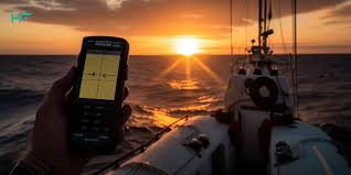
Fishing has evolved significantly with technology, and GPS fishing apps have become essential tools for anglers seeking to maximize their time on the water and increase their catch rates.
Modern anglers no longer rely solely on intuition and traditional methods. Today’s fishing enthusiasts harness the power of smartphone technology to locate fish, mark productive spots, and navigate waters with unprecedented precision.
GPS fishing apps have transformed from simple location markers into comprehensive fishing management systems that track weather patterns, water conditions, and even predict fish behavior.
Whether you’re a seasoned angler or just starting your fishing journey, understanding how GPS fishing apps work and which features matter most can dramatically improve your fishing success.
These digital companions offer capabilities that would have seemed like science fiction just a decade ago, putting advanced navigation and data analysis tools directly in your pocket.


🎣 What Makes GPS Fishing Apps Essential for Modern Anglers
GPS fishing apps have revolutionized how anglers approach their favorite sport. These applications combine satellite positioning technology with fishing-specific features to create a powerful tool that enhances every fishing trip.
The core functionality centers around precise location tracking, allowing fishermen to mark and return to productive fishing spots with accuracy measured in feet rather than general approximations.
Beyond simple waypoint marking, modern fishing GPS apps integrate real-time data such as weather forecasts, water temperatures, tidal information, and moon phases.
This comprehensive approach helps anglers make informed decisions about when and where to fish.
The ability to layer multiple data points creates a sophisticated understanding of fishing conditions that was previously available only to professional guides with years of local experience.
These apps also serve as digital fishing journals, automatically recording details about each catch including location, time, weather conditions, and bait used.
Over time, this creates a personalized database of patterns and trends unique to your fishing style and favorite waters. The insights gained from analyzing this data can reveal seasonal patterns, productive techniques, and optimal conditions for specific species.
📍 Key Features That Define Quality Fishing GPS Applications
Not all fishing GPS apps are created equal. The best applications distinguish themselves through a combination of essential features that directly impact fishing success.
Understanding these capabilities helps anglers choose the right tool for their specific needs and fishing environments.
Advanced Mapping and Navigation Capabilities
Superior fishing apps provide detailed maps that go far beyond basic topography. Look for applications offering bathymetric (underwater depth) maps, which reveal underwater structures, drop-offs, channels, and contours where fish typically congregate.
These depth maps transform flat water surfaces into three-dimensional underwater landscapes, giving anglers a significant advantage in locating productive areas.
Offline map functionality proves invaluable when fishing remote areas without cellular coverage. Quality apps allow users to download map sections for offline use, ensuring navigation and location marking capabilities remain functional regardless of signal availability.
This feature becomes critical when exploring new waters or fishing in wilderness areas.
Waypoint Management and Catch Logging
Effective waypoint systems allow anglers to mark specific locations with custom icons, colors, and detailed notes. The best apps enable unlimited waypoint storage with organizational features like folders, tags, and search functions.
This organizational capability becomes increasingly important as your collection of productive spots grows over time.
Integrated catch logging transforms your smartphone into a comprehensive fishing diary. Recording details such as species, size, bait, technique, and environmental conditions creates valuable data for pattern recognition.
Some advanced apps even support photo attachment and social sharing, allowing anglers to document trophy catches and share experiences with the fishing community.
Weather and Environmental Data Integration
Fish behavior closely correlates with environmental conditions, making weather integration a crucial feature.
Premium fishing GPS apps provide detailed forecasts including wind speed and direction, barometric pressure, precipitation, and temperature. Understanding how these factors influence fish activity helps anglers time their trips for maximum productivity.
Specialized data like solunar tables, which predict fish feeding activity based on moon phases and positions, adds another dimension to trip planning.
Tide predictions for saltwater anglers and water flow information for river fishermen complete the environmental picture, helping users identify optimal fishing windows.

🌊 How GPS Technology Improves Fishing Success Rates
The integration of GPS technology into fishing practices directly impacts catch rates through several mechanisms. First, the ability to return precisely to productive locations eliminates the guesswork that previously characterized spot-finding.
When you discover a productive honey hole, GPS coordinates ensure you can return to that exact location regardless of weather conditions, visibility, or time elapsed since your last visit.
GPS apps also enable efficient water coverage by tracking your trolling paths or drift patterns. This prevents redundant coverage of already-fished areas and helps identify productive depths and structures more systematically.
Many apps display breadcrumb trails showing your movement history, revealing patterns in your most successful fishing runs.
The data accumulation aspect cannot be overstated. Over months and years, the collected information about catches, conditions, and locations creates a personalized fishing intelligence database.
This historical perspective reveals long-term patterns that would be impossible to remember through memory alone, such as which spots produce during specific seasonal transitions or under particular weather conditions.
🚤 Types of Waters and How Apps Adapt
Different fishing environments present unique challenges that quality GPS fishing apps address through specialized features and map types. Understanding how your chosen application performs in your preferred fishing environment ensures you select the right tool for your needs.
Freshwater Lakes and Reservoirs
Lake fishing benefits enormously from bathymetric mapping that reveals underwater structure invisible from the surface. Drop-offs, submerged points, creek channels, and humps become clearly visible through depth contours.
GPS apps designed for lake fishing often include reservoir-specific features like generation schedules for dam-controlled waters and information about submerged timber or vegetation.
The ability to mark multiple spots and organize them by characteristics—such as depth, structure type, or target species—helps lake anglers build a comprehensive understanding of complex water systems.
Seasonal waypoint organization helps track how fish movements change throughout the year as water temperatures shift and forage patterns evolve.
Rivers and Streams
Flowing water presents different challenges than still water environments. River-specific GPS apps highlight features like current seams, eddies, pool locations, and access points.
Understanding river flow rates and how they change with seasonal runoff or dam releases becomes critical information for predicting fish locations and behavior.
Many river anglers appreciate apps that mark wading access points, parking areas, and navigable sections.
Safety features become particularly important in river environments, where knowing the locations of rapids, low-head dams, or other hazards can prevent dangerous situations.
Saltwater and Coastal Fishing
Marine GPS fishing apps excel when they integrate tidal information, showing how water movement affects fishing success at specific locations.
Coastal structure like jetties, reefs, wrecks, and artificial reefs become marked waypoints that produce consistently when fished during optimal tidal phases.
Offshore capabilities distinguish premium saltwater apps, with features supporting navigation to distant fishing grounds, trolling pattern tracking, and coordination with marine electronics.
Safety features like weather alerts and return-to-port navigation become essential when fishing beyond sight of land.
📱 Maximizing Your GPS Fishing App Experience
Simply downloading a fishing GPS app doesn’t guarantee improved results. Maximizing the benefits requires understanding best practices for data entry, organization, and strategic application of the information collected.
Consistent Data Entry Habits
Developing the discipline to log catches immediately—including detailed notes about conditions, techniques, and observations—creates the most valuable dataset.
Brief notes about water clarity, fish behavior, or bait presentation that produced strikes provide context that pure location data cannot capture. These details become increasingly valuable as you accumulate fishing history.
Accurate waypoint naming and categorization prevents confusion when you’ve marked dozens or hundreds of spots. Descriptive names that include location characteristics, target species, or season help you quickly identify relevant waypoints when planning trips.
Regular maintenance, removing outdated or unproductive waypoints, keeps your database manageable and useful.
Battery Management and Device Protection
GPS functionality drains smartphone batteries rapidly, making power management crucial for full-day fishing trips. Carrying portable battery packs, enabling power-saving modes, and closing unnecessary applications extends operational time.
Some anglers dedicate older smartphones exclusively to fishing, preserving their primary device’s battery for communication and emergencies.
Water, sun, and physical impacts threaten expensive smartphones on fishing trips. Quality waterproof cases rated for submersion protect against drops, splashes, and rain.
Mounting solutions that secure devices to boats or kayaks prevent loss while maintaining visibility and accessibility. Screen protectors guard against scratches from fish hooks, tackle, and rough handling.
🎯 Comparing Popular GPS Fishing App Options
The fishing app marketplace offers numerous options ranging from free basic tools to premium subscription services with comprehensive feature sets.
Understanding the landscape helps anglers select applications aligned with their fishing style, technical comfort level, and budget.
Entry-level apps provide basic waypoint marking and simple mapping, suitable for casual anglers or those just beginning to incorporate technology into their fishing.
These applications typically offer free versions with limited features or advertising support, allowing users to explore GPS fishing functionality without financial commitment.
Mid-tier applications balance feature richness with user-friendly interfaces, providing detailed mapping, catch logging, and weather integration at moderate subscription prices.
These apps serve the needs of serious recreational anglers who fish regularly and want to improve their success through data analysis and pattern recognition.
Premium applications offer professional-grade capabilities including advanced bathymetric mapping, sonar integration, community sharing features, and comprehensive environmental data.
These tools appeal to tournament anglers, fishing guides, and serious enthusiasts who view their subscription cost as an investment in fishing success.
🌐 Community Features and Social Fishing Networks
Modern GPS fishing apps increasingly incorporate social features that connect anglers, facilitate information sharing, and build communities around specific waters or species. These networking capabilities add value beyond individual trip planning and navigation.
Community waypoint sharing allows users to discover productive areas identified by other anglers, particularly valuable when fishing unfamiliar waters.
Privacy controls let users decide which information to share publicly versus keeping personal honey holes confidential. Many apps create heat maps showing fishing activity concentration, revealing generally productive areas without compromising specific spots.
Fishing reports and catch photos shared through app communities provide real-time information about current conditions and productive techniques.
This crowdsourced intelligence helps anglers make informed decisions about where to fish and what methods to employ. Tournament features allow competitive anglers to track leaderboards, submit catches, and verify results through GPS and photographic documentation.
💡 Advanced Techniques for Power Users
Experienced anglers extract maximum value from fishing GPS apps through advanced techniques that go beyond basic waypoint marking and navigation.
Pattern Analysis and Seasonal Planning
Analyzing historical catch data reveals patterns that guide future fishing decisions. Filtering catches by season, weather conditions, or moon phase identifies correlations that improve trip timing.
Mapping successful catches over time visualizes fish movement patterns and seasonal migrations within your fishing waters.
Creating seasonal waypoint sets acknowledges that productive locations change throughout the year as water temperatures shift and fish move to spawning, feeding, or wintering areas.
Organizing spots into spring, summer, fall, and winter categories helps you quickly identify relevant locations when planning trips.
Integration with Marine Electronics
Many advanced fishing GPS apps support integration with marine electronics like chartplotters and fish finders. Bidirectional waypoint sharing between devices ensures consistency across your fishing electronics ecosystem.
Some apps can display real-time sonar data from compatible fish finders, combining navigation with underwater imaging on a single device.
Route planning features allow pre-trip creation of trolling patterns, drift paths, or navigation routes that can be followed during fishing.
These planned routes ensure efficient water coverage and help you systematically explore productive depths or structures. Saved routes can be repeated on subsequent trips to compare results under different conditions.
🔒 Privacy Considerations and Waypoint Security
The digital nature of GPS fishing apps raises important privacy considerations regarding your fishing locations and personal information.
Understanding how apps handle your data and implementing appropriate security measures protects your most productive spots from unwanted attention.
Review privacy settings carefully, understanding which information is shared publicly, visible to friends, or kept completely private. Disable automatic social sharing if you prefer keeping your fishing activities confidential.
Some anglers create generic public waypoints in general areas while maintaining detailed private waypoints at exact productive locations.
Account security becomes crucial when your app contains years of accumulated fishing intelligence. Strong passwords, two-factor authentication where available, and regular data backups protect against loss due to device failure, theft, or account compromise.
Cloud synchronization ensures waypoints and catch logs remain accessible even if you lose or upgrade your smartphone.
🚀 Future Developments in Fishing GPS Technology
GPS fishing app technology continues evolving rapidly, with emerging capabilities promising even greater utility for anglers.
Artificial intelligence and machine learning algorithms are beginning to analyze fishing data, providing predictive recommendations about optimal fishing times, locations, and techniques based on current conditions and historical patterns.
Augmented reality features under development will overlay fishing information directly onto live camera views, displaying underwater structure, depth information, and marked waypoints superimposed on real-world water views.
This technology could revolutionize how anglers visualize underwater environments and navigate to productive spots.
Enhanced sensor integration will connect fishing apps with wearable devices, water quality sensors, and advanced fish finders, creating comprehensive environmental monitoring systems.
Real-time crowdsourced data from thousands of anglers could create dynamic fishing forecasts that predict activity levels with unprecedented accuracy.
⚓ Making GPS Fishing Apps Work for Your Style
Every angler fishes differently, and successful GPS app integration requires adapting the technology to your personal approach rather than forcing your fishing to accommodate the app.
Tournament anglers might emphasize route planning and rapid spot-hopping capabilities, while relaxed weekend fishermen may focus more on catch logging and photo documentation.
Experiment with different apps during lower-stakes fishing trips to identify which interfaces feel intuitive and which features you’ll actually use.
Many excellent applications go underutilized because their complexity overwhelms users, while simpler apps that match your needs deliver better practical value despite having fewer total features.
Start simple, mastering basic waypoint marking and navigation before exploring advanced features. As your comfort level grows, gradually incorporate catch logging, weather analysis, and pattern recognition capabilities.
This progressive approach prevents overwhelm and ensures you develop sustainable habits that enhance rather than distract from your fishing experience.
GPS fishing apps represent powerful tools that, when properly understood and consistently applied, significantly improve fishing success and enjoyment.
By marking productive locations, analyzing patterns, and making informed decisions based on comprehensive environmental data, anglers gain advantages that translate directly to more fish caught and more satisfying time on the water.
The investment in learning these technologies pays dividends throughout your fishing lifetime, creating an ever-growing knowledge base that makes each trip more productive than the last. 🎣