
Anúncios
Measuring land has never been easier thanks to modern technology that fits right in your pocket, transforming how property owners and professionals work.
Gone are the days when measuring a piece of land required expensive equipment, professional surveyors, or complicated mathematical calculations. Today’s smartphones come equipped with GPS technology and powerful sensors that make land measurement accessible to everyone, from farmers checking their crops to homeowners planning a garden renovation.
Whether you’re a real estate agent evaluating properties, a construction professional planning a new project, or simply a curious landowner wanting to know exactly how much space you have, land measurement apps offer precision and convenience that would have seemed impossible just a decade ago. Let’s explore everything you need to know about these remarkable tools.
📱 What Are Land Measurement Apps and How Do They Work?
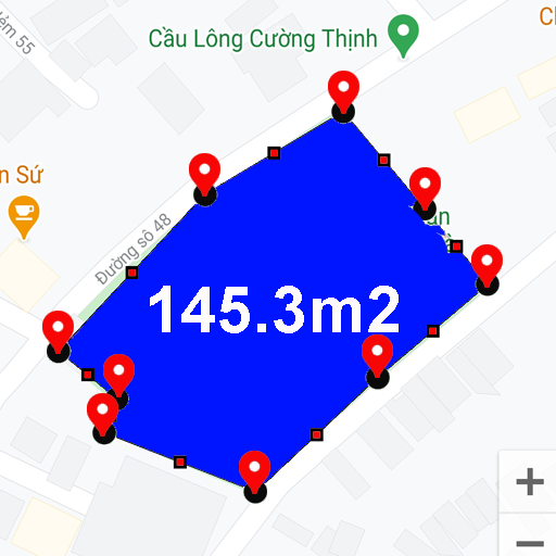
Land measurement apps leverage your smartphone’s built-in GPS capabilities to calculate distances, areas, and perimeters with remarkable accuracy. These applications use satellite positioning technology to track your movement as you walk around a property boundary, recording coordinates at each corner or turning point.
The magic happens through sophisticated algorithms that process these GPS coordinates to calculate the enclosed area. Most apps use the same mathematical principles that professional surveyors employ, applying formulas like the Shoelace theorem or Haversine formula to determine accurate measurements even on irregular-shaped plots.
Modern apps have evolved beyond basic GPS tracking to incorporate additional features like satellite imagery overlays, marking tools, and even augmented reality views. This combination of technologies provides users with multiple ways to verify measurements and visualize property boundaries in real-time.
🎯 Key Features That Make These Apps Indispensable
The best land measurement applications come packed with features designed to make your measuring tasks effortless and accurate. Understanding these capabilities helps you choose the right tool for your specific needs.
GPS Tracking and Waypoint Marking
The foundation of any quality land measurement app is reliable GPS tracking. As you walk the perimeter of your property, the app records your path with precision. You can mark specific waypoints at corners or important landmarks, ensuring your measurements account for every angle and curve.
Advanced apps allow you to pause and resume tracking, perfect for when you need to navigate around obstacles or take a break during large property measurements. This flexibility ensures you never lose your progress on extensive surveying projects.
Multiple Measurement Units
Professional apps support various measurement units to accommodate international users and different industry standards. You can instantly switch between square meters, acres, hectares, square feet, and other units without recalculating anything manually.
This versatility proves invaluable when communicating with different stakeholders who may prefer specific measurement systems, saving time and reducing confusion in property transactions or planning discussions.
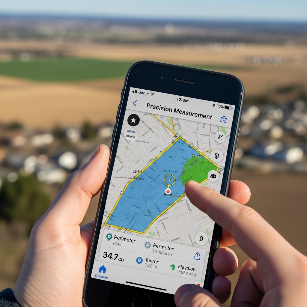
Satellite and Map Integration
Premium land measurement apps integrate with Google Maps, satellite imagery, and topographic maps. This visual component allows you to see your measurements overlaid on actual terrain, providing context that raw numbers alone cannot convey.
You can zoom in for detailed views or zoom out to understand how your property relates to surrounding areas, roads, and natural features. This spatial awareness enhances decision-making for development, agriculture, or conservation projects.


🌾 Practical Applications Across Different Industries
Land measurement apps serve diverse purposes across numerous professions and personal projects. Their versatility makes them valuable tools regardless of your specific field or interest.
Agriculture and Farming
Farmers use these apps daily to measure field sizes for crop planning, irrigation system design, and fertilizer calculations. Knowing the exact area helps optimize resource allocation and maximize yields while minimizing waste.
Precision agriculture relies heavily on accurate field measurements. Whether dividing plots for crop rotation or calculating harvest expectations, these apps provide the data farmers need to make informed agricultural decisions.
Real Estate and Property Development
Real estate professionals appreciate the ability to quickly verify property boundaries during site visits. Instead of relying solely on old surveys or vague descriptions, agents can measure properties on the spot, providing clients with immediate, accurate information.
Developers use these tools during initial site assessments to estimate development potential, calculate building footprints, and plan infrastructure layouts. This preliminary data helps determine project feasibility before investing in expensive professional surveys.
Construction and Landscaping
Contractors measuring sites for fencing, paving, or landscaping projects benefit from instant area calculations. These measurements help generate accurate quotes, order appropriate material quantities, and plan labor requirements efficiently.
Landscapers designing gardens, lawns, or outdoor spaces use measurement apps to calculate areas for turf, mulch, pavers, and other materials. This precision reduces material waste and ensures projects stay within budget.
Environmental Conservation
Environmental organizations and researchers employ land measurement apps to document habitat sizes, track deforestation, and monitor conservation areas. The ability to quickly record geographic data in the field accelerates research and conservation efforts.
Wildlife corridors, protected zones, and restoration areas all require accurate boundary documentation. These apps provide conservationists with accessible tools to gather essential data without extensive technical training.
🔍 Accuracy Considerations and Best Practices
While land measurement apps offer impressive accuracy, understanding their limitations and following best practices ensures you get the most reliable results possible.
GPS Signal Quality Matters
GPS accuracy depends heavily on satellite signal quality. Open areas with clear sky views provide the best results, typically achieving accuracy within 3-5 meters. Dense forests, tall buildings, or deep valleys can interfere with signals, reducing precision.
For optimal accuracy, measure during clear weather conditions and avoid times when atmospheric interference peaks. Some apps display signal strength indicators, helping you assess measurement reliability in real-time.
Walking the Perimeter Correctly
Proper technique significantly impacts measurement accuracy. Walk steadily along property boundaries, holding your phone at a consistent height and position. Avoid rapid movements or irregular paths that might confuse the GPS tracking.
For irregular boundaries or properties with many corners, mark waypoints carefully at each turning point. Take your time at corners to ensure the app registers the direction change accurately.
Calibration and Device Considerations
Different smartphones have varying GPS chip quality and antenna designs. Higher-end devices generally provide better accuracy than budget models. Ensure your device’s location services are set to high accuracy mode and that GPS is properly calibrated.
Some apps include calibration tools or accuracy enhancement features. Familiarize yourself with these options and use them before important measurements to optimize your results.
Verification and Cross-Checking
For critical measurements, consider verifying results through multiple methods. Measure the same area twice using different apps or compare your results with satellite imagery measurements. Professional surveys remain the gold standard for legal documentation and major transactions.
Use measurement apps as preliminary tools or for general purposes, understanding they provide excellent estimates but may not replace professional surveying for legal boundaries or high-stakes projects.
💡 Choosing the Right App for Your Needs
The app marketplace offers numerous land measurement options, each with unique features and pricing models. Selecting the right one depends on your specific requirements and usage frequency.
Free vs. Premium Options
Many quality land measurement apps offer free versions with basic functionality suitable for occasional users or simple measurements. These typically include standard area calculation, basic mapping, and limited save options.
Premium versions unlock advanced features like unlimited saved measurements, detailed reporting, export options, enhanced accuracy tools, and ad-free experiences. Professionals and frequent users often find premium subscriptions worthwhile for the added capabilities and time savings.
User Interface and Learning Curve
Intuitive design makes the difference between an app you’ll use regularly and one that sits forgotten on your phone. Look for applications with clear instructions, visual guides, and straightforward navigation that doesn’t require extensive technical knowledge.
The best apps balance powerful features with accessible interfaces, allowing beginners to start measuring immediately while providing depth for advanced users who want granular control over settings and outputs.
Compatibility and Integration
Consider whether you need data export capabilities for integration with other software systems. Some apps allow you to export measurements to CAD programs, spreadsheets, or project management tools, streamlining workflows across different platforms.
Cloud synchronization features enable accessing your measurements across multiple devices and backing up important data automatically. This functionality proves valuable for teams collaborating on projects or professionals working from multiple locations.
📊 Advanced Features for Professional Users
Professional-grade measurement apps include sophisticated tools that extend beyond basic area calculation, providing comprehensive surveying capabilities right from your smartphone.
Slope and Elevation Tracking
Understanding terrain elevation changes helps with drainage planning, construction grading, and agricultural applications. Advanced apps incorporate elevation data to calculate not just flat area but also account for slopes and topographic variations.
This three-dimensional perspective provides more accurate volume calculations for earthwork projects, helping contractors estimate excavation or fill requirements with greater precision.
Distance and Perimeter Tools
Beyond area measurements, professional apps offer point-to-point distance calculations, perimeter measurements, and the ability to measure multiple segments within a property. These tools help with fence planning, road layouts, and utility line routing.
Some applications include angle measurement features, allowing you to document property corners and boundary angles for more detailed documentation or planning purposes.
Photo Documentation and Annotation
Integrating photos with measurements creates comprehensive property records. Capture images of boundary markers, terrain features, or existing structures, then annotate them with measurements and notes directly within the app.
This visual documentation proves invaluable for communicating with clients, obtaining permits, or creating detailed project proposals that combine accurate data with real-world context.
🌍 Real-World Success Stories and Use Cases
Understanding how others successfully use land measurement apps illustrates their practical value and inspires creative applications you might not have considered.
A family farm in the Midwest used a measurement app to document their entire property, dividing it into management zones for precision agriculture. By accurately measuring each zone, they optimized fertilizer application, reducing costs by 18% while improving crop yields through targeted resource allocation.
A real estate investor evaluating potential development properties saves thousands of dollars in preliminary surveying costs by using measurement apps for initial assessments. Once a property shows promise, professional surveys confirm the data, but the app eliminates wasted money on unsuitable lots.
An environmental nonprofit documented deforestation patterns in remote areas by training local volunteers to use measurement apps. This grassroots data collection approach enabled monitoring across vast territories without expensive equipment or extensive technical training.
A landscape designer transformed their client consultation process by measuring properties during initial site visits. Immediate area calculations allow for on-the-spot design discussions and preliminary quotes, improving customer satisfaction and accelerating project timelines.
🔧 Troubleshooting Common Measurement Challenges
Even the best apps occasionally encounter issues. Knowing how to address common problems ensures consistent results and reduces frustration.
Inconsistent GPS Readings
If measurements seem erratic, check for physical obstructions blocking satellite signals. Move away from buildings, large vehicles, or dense tree cover. Wait a few minutes for your device to lock onto multiple satellites, which improves accuracy significantly.
Airplane mode cycling can help reset GPS connections when experiencing persistent issues. Toggle airplane mode on for 30 seconds, then off, allowing your device to reconnect with better satellite acquisition.
Battery Drain During Long Measurements
GPS tracking consumes considerable battery power, especially during extended surveying sessions. Carry a portable charger or ensure your phone starts fully charged before tackling large properties.
Some apps include battery-saving modes that reduce screen brightness or limit background processes while maintaining measurement accuracy. Enable these features during lengthy field sessions to extend operating time.
Saving and Managing Multiple Measurements
Organizing numerous measurements requires good naming conventions and folder structures within your app. Develop a consistent system using property names, dates, or project numbers to quickly locate specific measurements later.
Regular backups prevent data loss from device failures or accidental deletions. Use cloud storage or export important measurements to external storage systems for safekeeping.
🚀 Future Trends in Land Measurement Technology
The evolution of smartphone technology and GPS systems promises even more capable measurement tools in coming years. Understanding these trends helps prepare for emerging capabilities.
Augmented reality integration will overlay property boundaries and measurements directly onto your camera view, making visualization effortless. Imagine pointing your phone at a property and seeing boundaries, dimensions, and area calculations superimposed on the real-world view.
Improved satellite networks and multi-GNSS support will enhance accuracy significantly. New global positioning satellites provide better coverage and precision, potentially achieving survey-grade accuracy from consumer devices.
Artificial intelligence will automate boundary detection from satellite imagery, allowing apps to suggest property outlines that you simply confirm rather than manually tracing. Machine learning algorithms will also improve error correction and measurement refinement.
Integration with drone technology represents another frontier. Apps that coordinate with affordable consumer drones could provide aerial measurement capabilities, combining ground GPS with overhead photogrammetry for unprecedented accuracy and comprehensive property documentation.
✅ Making the Most of Your Measurement App
Maximizing the value of land measurement apps requires moving beyond basic functionality to incorporate these tools into your regular workflow and decision-making processes.
Develop measurement routines that ensure consistency across projects. Follow the same procedures each time, from calibration through data recording, creating reliable comparative data that helps track changes over time.
Combine app measurements with other data sources for comprehensive property analysis. Integrate your area calculations with soil testing results, water availability assessments, or market research to make well-rounded decisions about property use and development.
Share your findings effectively by learning your app’s export and reporting features. Professional-looking reports with maps, measurements, and photos communicate information clearly to clients, partners, or stakeholders, enhancing your credibility and project outcomes.
Stay updated with app improvements and new features through regular updates. Developers continuously enhance functionality based on user feedback, and keeping your app current ensures access to the latest accuracy improvements and capabilities.
Land measurement apps represent a democratization of technology that was once exclusive to professionals with specialized equipment. Today, anyone with a smartphone can measure property accurately, plan projects confidently, and make informed decisions about land use and development. Whether you’re managing farmland, evaluating real estate, planning construction, or simply satisfying curiosity about your property, these powerful tools put professional-grade capabilities literally in your hands. As technology continues advancing, the gap between consumer apps and professional surveying equipment will narrow even further, making precise land measurement accessible to everyone who needs it. 🌟